Bridge-related Points of Interest on the Chicago River
(Numbers below correspond to map locations - click on number to jump to description)
Bridge-related Points of Interest on the Chicago River
(Numbers below correspond to map locations - click on number to jump to description)
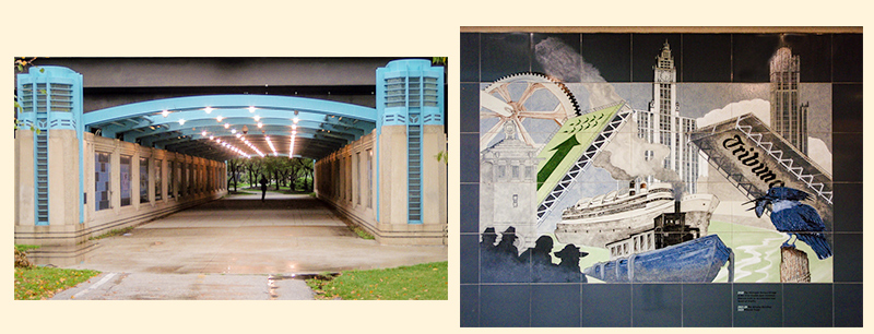
The east portal of the Riverwalk Gateway (L) and the tile panel depicting significant structures built at the Michigan Ave. river crossing in the 1920's - Wrigley Building, Tribune Tower, and the Michigan Ave. bridge.(R).
The “Riverwalk Gateway” is a public art installation by Ellen Lanyon that has a number of events from Chicago history depicted on tile panels. It is located at the east end of the riverwalk and runs under N. Lake Shore Dr. just south of the river. You can access the gateway from either the lake front on the east or from the Riverwalk on the west.
If you find yourself walking across N. Lake Shore Drive bridge to or from Navy Pier, this is on your way. You will find it at the base of the SW stairway of the bridge.
******
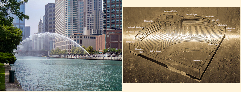
The Centennial Fountain in action (L). The plaque on the fountain depicting the flow of water from Lake Michigan (R).
The Nicholas J. Melas Centennial Fountain is located at 300 N McClurg Ct. on the north side of the river (about half way between the bridges at N. Columbus and N. Lake Shore Drives). The fountain’s water arc shoots across the river. There are viewing areas on both sides of the river.
The fountain commemorates the 100th anniversary of the Metropolitan Water Reclamation District’s efforts to protect the water supply of Lake Michigan. The major part of this effort was reversing the flow of the Chicago River in 1900.
Completed in 1989, the fountain symbolizes the path of the waters from Lake Michigan to the Atlantic Ocean and the Gulf of Mexico.
In the past the fountain has been activated on the hour for 5 minutes from 10AM to midnight daily from May 1 - October 31 (confirm schedule).
******
3. McCormick Bridgehouse & Chicago River Museum
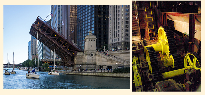
The McCormick Bridgehouse & Chicago River Museum (L). A view of the gears visible in the museum (R).
The McCormick Bridgehouse & Chicago River Museum is located in the SW bridgehouse of the N. Michigan Avenue / DuSable bridge. The museum occupies the entire five levels of the bridgehouse focusing on the intertwined histories of Chicago and its river. A bonus feature of the museum is the viewing area of the machinery that operates the N. Michigan Avenue bridge.
The museum is open from mid-May through October, Thursday-Monday. There are limited opportunities to view the bridge during operation (see schedule). It is operated by Friends of the Chicago River.
******
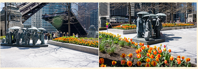
N. Wabash Ave. bridgehouses (L). N. State St. bridgehouses in the foreground & N. Dearborn St. bridgehouse in the background (R). It is not uncommon for visitors to interact with the "Gentlemen" (seen in both photos).
The AMA Plaza is located on the north side of the river between the N. Wabash Ave. and N. State St. bridges (330 N. Wabash in front of the Langham Hotel). Even though it is at street level, it provides a great open space to enjoy the river below.
In the context of current Chicago bridges, this one location allows you to easily contrast bridges from the three bridge eras represented in the Loop (1913-1930 Beaux-arts; 1935-1950 Art-deco; and post 1950 “modern”). These eras are most easily determined by observing the architectural style of the bridgehouses. The N. Wabash Ave bridge is the representative from the Beaux-Arts era; N. State St. bridge represents the Art-Deco period; and the N. Dearborn St. bridge represents the “modern” style.
During boat runs this location provides a great vantage post to watch both bridges rise. The landscaping and the public art (“Gentlemen” by Ju Ming) provide a relaxing space to enjoy the river away from the hubbub that sometimes encompasses the Riverwalk.
******
5. N. Dearborn & N. Clark St. crossings
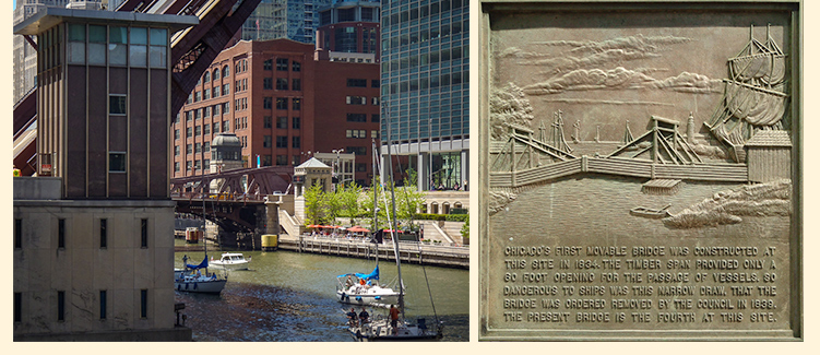
N. Dearborn St. (foreground) & N. Clark St. (background) bridges (L). Plaque about the first Dearborn St. bridge. (R)
Anywhere between the N. Dearborn St. and N. Clark St. bridges on the Riverwalk.
This is a “bridge history geek” spot. Chicago’s movable bridge history started in 1834 and continues today. What we see on the river today is just the current snapshot in that history.
If you were at this spot circa 1834, you would have seen Chicago’s first movable bridge at Dearborn St. (a plaque commemorates this bridge on the NE corner of the bridge - Dearborn history). Fast forward a few years to 1840 and you would have seen one of Chicago’s early pontoon movable bridges at Clark St. (Clark history).
Both of these locations have had center pier swing bridges. The swing bridge at Clark St. was the last one removed on the Main Stem in 1929. The last swing bridge at N. Dearborn St. was replaced by a Scherzer rolling lift bridge in 1907. The current bridge at N. Dearborn St. opened in 1963.
******
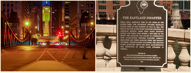
The La Salle St. canyon at night (L). The Eastland Disaster plaque (R).
The SE corner of the N. La Salle St. bridge is where you will find the marker commemorating the Eastland Disaster of July 24, 1915 (read about it). Note that there was no bridge at La Salle St. at that time and the Clark St. bridge was a center pier swing bridge.
Walking across the bridge to the north side of the river, you will find a median that will allow you to look back south along the La Salle St. canyon to the Board of Trade building. If you wait long enough, the L will cross your view. It’s a nice spot for a photo.
A side comment about the number of bridgehouses. The Loop bridges have as many as four bridgehouses and as few as one bridgehouse, but most have two. Why? From 1913 to 1950 one house was needed to operate each leaf. Post 1950, technical advancements allowed both leaves to be operated from a single house. Four bridgehouses were an architectural statement used for "important" locations or gateways. Bridges at N. Lake Shore Dr. (gateway into the city from Lake Michigan), N. Michigan Ave. (gateway from south to north), and N. La Salle St. (gateway to the financial district) all have four bridgehouses.
******
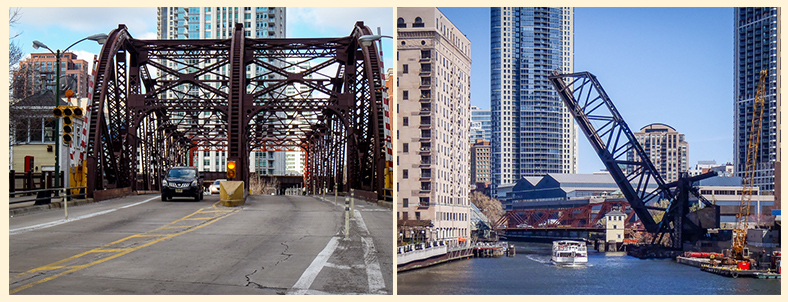
Street level view of the south end of the N.Kinzie St. bridge (L). View of the N. Kinzie St. and Carroll Ave. RR bridges (R).
The N. Kinzie St. bridge is one block north of Wolf Point (where the Chicago River divides). While not technically in my grouping of “Loop Bridges,” this bridge is easy to access and historically interesting.
The N. Kinzie St. bridge is a single leaf, 1st generation Chicago-type bascule bridge. The humpback profile, characteristic of the 1st generation bridges, is caused by the placement of the gearing used to raise the bridge. This gearing can be seen on the back side of the the supporting trusses. The 2nd & 3rd generation Chicago-type bascules that make up the "Loop Bridges" have the gearing on the inside of the supporting trusses which allowed for more diversity in their profiles.
Located just south of the N. Kinzie St. bridge is the perpetually raised Carroll Ave. RR bridge. This single leaf Strauss designed bascule is unusual in the downtown area because of its overhead counter weight.
Both of these bridges are still operable. The RR bridge is lowered once a year to preserve the Union Pacific Railroad’s right-of-way to cross the river. When lowered this bridge has limited clearance for vessels on the river. With the number of architectural river cruises that would require this bridge to be raised, it makes more sense to just leave it in the raised position. The N. Kinzie St. bridge is seldom raised but is maintained as operable for river traffic exceeding its clearance in the lowered position.
Additional information on the Kinzie St. bridges
******
8. W. Randolph St. & W. Washington Blvd. crossings on the South Branch
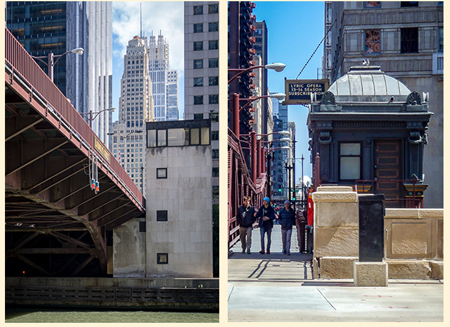
The youngest bridge at W. Randolph St. (L) & the oldest at W. Washington Blvd. (R).
The W. Randolph St. and W. Washington Blvd. bridges are best viewed from the Riverside Plaza in front of the Boeing Building (100 N. Riverside Plaza).
This is another “bridge history geek” spot. From this location you can contrast the youngest Loop Bridge at W. Randolph St. (1984) with the oldest Loop Bridge at W. Washington Blvd (1913). Remember, what we see today is just a snap shot in history. There has been a crossing at Randolph St. about 30 years longer than at Washington Blvd. (Randolph St. history & Washington Blvd. history).
******
9. 100 year old Loop Bridges - South Branch
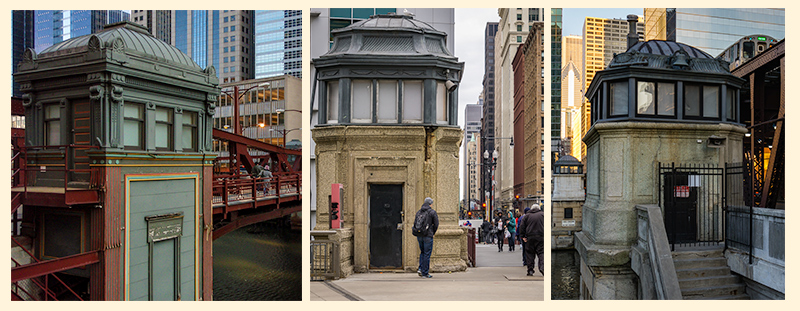
W. Washington Blvd. (L), W. Jackson Blvd. (C), & W. Lake St. (R).
There are three Loop Bridges that have reached the century mark, all on the South Branch. They are not conveniently bunched together but worth a look. You can find them at W. Washington Blvd., W. Jackson Blvd., and W. Lake St.